
YELLOWMAPS
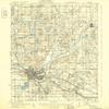
YellowMaps Battle Creek MI topo map, 1:62500 Scale, 15 X 15 Minute, Historical, 1918, Updated 1932, 19.7 x 16.3 in - Tyvek
₪589.24
₪982.07
Save 40% (₪392.83)
-
 Order within 23 hours and 25 minutes to get between June 11 - June 17
 -
 Tracked Shipping on All Orders
-
 14-Day Returns
- Secure Payments
-
 24/7 Customer Support
Description
- Printed on Tyvek (synthetic)
- USGS topographic map of Battle Creek, MI, at 1:62500 scale. Lighter material. Waterproof. Tear-resistant. Foldable. Very durable. Perfect for backpacking and the outdoors.
- Cities, towns, villages: Greenfield Park,Brownlee Park,Maplehurst,Old Mill Gardens,Springfield Place,Verona Park,Urbandale,Springfield,Battle Creek,Wattles Park,Beadle Lake,Assyria,Orchard Park,Lakeview,Sunrise Heights,Morgan Corners,Bedford,Ceresco,Bellevue,Lacey,Pennfield
- Mountains: High elevation topographical features like high summits and peaks.
- Valleys: Low elevation topographic features such as flatlands, river valleys, and canyons.
Shipping and Returns
- We offer tracked shipping on all orders. Tracking information will be shared as soon as the order is dispatched.
- Please check the delivery estimate before adding a product to the cart. This is displayed for every product on the website.
- Available shipping methods and charges will be displayed at the time of checkout, depending on your exact location.
- All customers are entitled to a return window of 14 days, starting from the date of delivery of the product(s).
- Customers are advised to read our return policy for details of the return process, eligibility, refunds as well as cancellations or exchanges.
- In case of any issues or concerns about Shipping or Returns, please contact us and we will be happy to help.
YellowMaps.
YellowMaps Battle Creek MI topo map, 1:62500 Scale, 15 X ...
₪589.24
₪982.07
Save 40.0% (₪392.83)