
YELLOWMAPS
YellowMaps Barco NC topo map, 1:62500 Scale, 15 X 15 Minute, Historical, 1940, 22 x 18 in - Polypropylene
₪531.71
₪886.18
Save 40% (₪354.47)
-
 Order within 20 hours and 30 minutes to get between June 11 - June 17
 -
 Tracked Shipping on All Orders
-
 14-Day Returns
- Secure Payments
-
 24/7 Customer Support
Description
- Printed on Polypropylene (plastic)
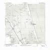
- USGS topographic map of Barco, NC, at 1:62500 scale. Heavier material. Waterproof. Tear-resistant. Foldable. Perfect for the outdoors.
- Cities, towns, villages: Poyners Hill (historical),Aydlett,Barco,Corolla,Coinjock,Poplar Branch,Ocean Hills,Bertha,Waterlily
- Islands: Mate Island,Long Island,Raymond Island,Brant Island,Goat Island,Buck Island,Cedar Island,Bell Island,Buck Island
- Parks and forests: Currituck National Wildlife Refuge,Outer Banks Center for Wildlife Education
Printed on Polypropylene
Shipping and Returns
- We offer tracked shipping on all orders. Tracking information will be shared as soon as the order is dispatched.
- Please check the delivery estimate before adding a product to the cart. This is displayed for every product on the website.
- Available shipping methods and charges will be displayed at the time of checkout, depending on your exact location.
- All customers are entitled to a return window of 14 days, starting from the date of delivery of the product(s).
- Customers are advised to read our return policy for details of the return process, eligibility, refunds as well as cancellations or exchanges.
- In case of any issues or concerns about Shipping or Returns, please contact us and we will be happy to help.
YellowMaps.
YellowMaps Barco NC topo map, 1:62500 Scale, 15 X 15 Minu...
₪531.71
₪886.18
Save 40.0% (₪354.47)