
YELLOWMAPS
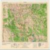
YellowMaps Ardmore OK topo map, 1:250000 Scale, 1 X 2 Degree, Historical, 1963, Updated 1963, 23.1 x 32.6 in - Tyvek
₪593.95
₪989.92
Save 40% (₪395.97)
-
 Order within 37 minutes to get between June 10 - June 16
 -
 Tracked Shipping on All Orders
-
 14-Day Returns
- Secure Payments
-
 24/7 Customer Support
Description
- Printed on Tyvek (synthetic)
- USGS topographic map of Ardmore, OK, at 1:250000 scale. Lighter material. Waterproof. Tear-resistant. Foldable. Very durable. Perfect for backpacking and the outdoors.
- Cities, towns, villages: Caney,Whitebead,Armstrong,Rush Springs,Wasseta,Pickett,Silo,McCarty,Stringtown,Kenefic,Hope,Davis,Clemscott,Fort Washita,Cottonwood,Ury,Linn,Durwood,Old Scott,Vamoosa,Nebo,Pruitt City,Ravia,Wilson,Calvin,Story,Citra,Hickory,Hird,Pernell,Oklahoma Hills,Chism,McMillan,Mannsville,Healdton,Foster,Latta,Rexroat,Dripping Springs,Oakland,Fitzhugh,Harden City,Orr,Alma,Wynnewood
- Mountains: Jack Hills,Arbuckle Mountains,Criner Hills,Caddo Hills,Burning Mountain,Robbers Roost,Buffalo Head,Tenmile Hill,Petticoat Hill,Mount Airy,Biscuit Knob,White Mound,Horseshoe Mountain,Table Hill,Brushy Mountain,Chimney Hill,Bromide Hill,Yellow Hill
- Valleys: Pine Hollow,King Hollow,Sycamore Hollow,Dry Hollow,Thomas Hollow,Phillips Hollow,Bobcat Gulch,Clear Canyon,Reeves Ravine,Redoak Hollow,Weed Hollow,Hudlow Hollow,Townley Hollow,Prairie H
USGS topographic map of Ardmore, Oklahoma, dated 1963, updated 1963.
Includes geographic coordinates (latitude and longitude), lines of elevation, bodies of water, roads, and more. This topo quad is suitable for recreational, outdoor uses, office applications, or wall map framing.
Printed on-demand by YellowMaps on the print material of your choice.
Shipping rolled from Minneapolis, MN, United States.
Product Number: USGS-5473147
Map Size: 23.1 inches high x 32.6 inches wide
Map Scale: 1:250000
Map Type: POD USGS Topographic Map
Map Series: HTMC
Map Version: Historical
Cell ID: 68649
Scan ID: 800772
Imprint Year: 1963
Woodland Tint: Yes
Aerial Photo Year: 1958
Edit Year: 1957
Datum: Unstated
Map Projection: Transverse Mercator
Map published by United States Geological Survey
Map Language: English
Scanner Resolution: 508 dpi
Map Cell Name: Ardmore
Grid size: 1 X 2 Degree
Date on map: 1963
Geographical region: Oklahoma, United States
Northern map edge Latitude: 35
Southern map edge Latitude: 34
Western map edge Longitude: -98
Eastern map edge Longitude: -96
Surrounding map sheets (copy & paste the Product No. in the search bar):
North: USGS-5472879,USGS-5473187,USGS-5469129,USGS-5472771,USGS-5469127
East: USGS-5472715,USGS-5468855,USGS-5638343,USGS-5472856,USGS-5472852
South: USGS-5471835,USGS-5481155,USGS-5479867,USGS-5638409,USGS-5480623
West: USGS-5473171,USGS-5472431,USGS-5473169,USGS-5479743,USGS-5473165
Shipping and Returns
- We offer tracked shipping on all orders. Tracking information will be shared as soon as the order is dispatched.
- Please check the delivery estimate before adding a product to the cart. This is displayed for every product on the website.
- Available shipping methods and charges will be displayed at the time of checkout, depending on your exact location.
- All customers are entitled to a return window of 14 days, starting from the date of delivery of the product(s).
- Customers are advised to read our return policy for details of the return process, eligibility, refunds as well as cancellations or exchanges.
- In case of any issues or concerns about Shipping or Returns, please contact us and we will be happy to help.
YellowMaps.
YellowMaps Ardmore OK topo map, 1:250000 Scale, 1 X 2 Deg...
₪593.95
₪989.92
Save 40.0% (₪395.97)