
YELLOWMAPS
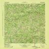
YellowMaps Appling GA topo map, 1:62500 Scale, 15 X 15 Minute, Historical, 1943, 21.7 x 17.7 in - Polypropylene
₪531.71
₪886.18
Save 40% (₪354.47)
-
 Order within 20 hours and 29 minutes to get between June 11 - June 17
 -
 Tracked Shipping on All Orders
-
 14-Day Returns
- Secure Payments
-
 24/7 Customer Support
Description
- Printed on Polypropylene (plastic)
- USGS topographic map of Appling, GA, at 1:62500 scale. Heavier material. Waterproof. Tear-resistant. Foldable. Perfect for the outdoors.
- Cities, towns, villages: Eubank (historical),Shiloh (historical),Ansley Mill,Leathersville,Leah,Scuffletown,Howell,Agnes (historical),Delph (historical),New Hope,Stones Crossroads,Loce,Cluese (historical),Amity,Rousseau Spring (historical),Bussey,Maddox,Clay Hill,Cobbham Crossroads,Hamilton Crossroads,Dunn Chapel,Cobbham,Appling,Woodlawn,Pollards Corner,Raysville,Winfield Hill,Winfield,Phinizy,Salem (historical)
- Islands: Price Island (historical)
- Parks and forests: Keg Creek State Park,Marshall Monument,Fort Gordon Recreation Area,Mistletoe State Park
Printed on Polypropylene
Shipping and Returns
- We offer tracked shipping on all orders. Tracking information will be shared as soon as the order is dispatched.
- Please check the delivery estimate before adding a product to the cart. This is displayed for every product on the website.
- Available shipping methods and charges will be displayed at the time of checkout, depending on your exact location.
- All customers are entitled to a return window of 14 days, starting from the date of delivery of the product(s).
- Customers are advised to read our return policy for details of the return process, eligibility, refunds as well as cancellations or exchanges.
- In case of any issues or concerns about Shipping or Returns, please contact us and we will be happy to help.
YellowMaps.
YellowMaps Appling GA topo map, 1:62500 Scale, 15 X 15 Mi...
₪531.71
₪886.18
Save 40.0% (₪354.47)