
YELLOWMAPS
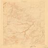
YellowMaps Apishapa CO topo map, 1:125000 Scale, 30 X 30 Minute, Historical, 1897, Updated 1910, 19.8 x 16.2 in - Tyvek
₪589.24
₪982.07
Save 40% (₪392.83)
-
 Order within 23 hours and 24 minutes to get between June 11 - June 17
 -
 Tracked Shipping on All Orders
-
 14-Day Returns
- Secure Payments
-
 24/7 Customer Support
Description
- Printed on Tyvek (synthetic)
- USGS topographic map of Apishapa, CO, at 1:125000 scale. Lighter material. Waterproof. Tear-resistant. Foldable. Very durable. Perfect for backpacking and the outdoors.
- Cities, towns, villages: Cedar Crest,Houghton,Whiterock,Rock Crossing,Delhi
- Mountains: Sanford Hills,Smith Hollow Hills,Big Arroyo Hills,Tater Hill,Brushy Knob,South Rattlesnake Butte,Mica Butte,Gobblers Knob,Little Dome,North Rattlesnake Butte,Flattop Butte,Sawtooth Peak,Tyler Hill,Haystack Butte,Blue Hill,Haystack,Cone Pinnacle
- Valleys: Juan Baca Canyon,McElhaney Canyon,Tinaja Canyon,Myers Canyon,Hudson Canyon,South Canyon,Christian Canyon,West Cross Canyon,East Draw,East Cross Canyon,Averson Canyon,Buck Canyon,Lambing Canyon
USGS topographic map of Apishapa, Colorado, dated 1897, updated 1910.
Includes geographic coordinates (latitude and longitude), lines of elevation, bodies of water, roads, and more. This topo quad is suitable for recreational, outdoor uses, office applications, or wall map framing.
Printed on-demand by YellowMaps on the print material of your choice.
Shipping rolled from Minneapolis, MN, United States.
Product Number: USGS-5359117
Map Size: 19.8 inches high x 16.2 inches wide
Map Scale: 1:125000
Map Type: POD USGS Topographic Map
Map Series: HTMC
Map Version: Historical
Cell ID: 64898
Scan ID: 403004
Imprint Year: 1910
Survey Year: 1896
Datum: Unstated
Map Projection: Unstated
Map published by United States Geological Survey
Map Language: English
Scanner Resolution: 508 dpi
Map Cell Name: Apishapa
Grid size: 30 X 30 Minute
Date on map: 1897
Geographical region: Colorado, United States
Northern map edge Latitude: 38
Southern map edge Latitude: 37.5
Western map edge Longitude: -104.5
Eastern map edge Longitude: -104
Surrounding map sheets (copy & paste the Product No. in the search bar):
North: USGS-5359489,USGS-5359495,USGS-5359493,USGS-5349075,USGS-5359487
East: USGS-5359041,USGS-5352519,USGS-5359619,USGS-5359617,USGS-5359615
South: USGS-5359245,USGS-5359251,USGS-5359249,USGS-5359257,USGS-5359247
West: USGS-5359675,USGS-5359669,USGS-5359665,USGS-5354971,USGS-5359667
Shipping and Returns
- We offer tracked shipping on all orders. Tracking information will be shared as soon as the order is dispatched.
- Please check the delivery estimate before adding a product to the cart. This is displayed for every product on the website.
- Available shipping methods and charges will be displayed at the time of checkout, depending on your exact location.
- All customers are entitled to a return window of 14 days, starting from the date of delivery of the product(s).
- Customers are advised to read our return policy for details of the return process, eligibility, refunds as well as cancellations or exchanges.
- In case of any issues or concerns about Shipping or Returns, please contact us and we will be happy to help.
YellowMaps.
YellowMaps Apishapa CO topo map, 1:125000 Scale, 30 X 30 ...
₪589.24
₪982.07
Save 40.0% (₪392.83)