
YELLOWMAPS
YellowMaps Anchorage A 7 AK topo map, 1:63360 Scale, 15 X 15 Minute, Historical, 1960, Updated 1961, 20.8 x 17.1 in - Tyvek
₪589.24
₪982.07
Save 40% (₪392.83)
-
 Order within 33 minutes to get between June 10 - June 16
 -
 Tracked Shipping on All Orders
-
 14-Day Returns
- Secure Payments
-
 24/7 Customer Support
Description
- Printed on Tyvek (synthetic)
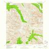
- USGS topographic map of Anchorage A 7, AK, at 1:63360 scale. Lighter material. Waterproof. Tear-resistant. Foldable. Very durable. Perfect for backpacking and the outdoors.
- Cities, towns, villages: Please see map preview to find populated places, townships, as well as roads and street names if available.
- Mountains: Mount Williwaw,O'Malley Peak,Cantata Peak,Bird Peak,The Wedge,Indianhouse Mountain,The Ramp,Little Teton Mountain,Hurdygurdy Mountain,Wolverine Peak,Temptation Peak,Harp Mountain,Suicide Peaks
- Valleys: Low elevation topographic features such as flatlands, river valleys, and canyons.
USGS topographic map of Anchorage A 7, Alaska, dated 1960, updated 1961.
Includes geographic coordinates (latitude and longitude), lines of elevation, bodies of water, roads, and more. This topo quad is suitable for recreational, outdoor uses, office applications, or wall map framing.
Printed on-demand by YellowMaps on the print material of your choice.
Shipping rolled from Minneapolis, MN, United States.
Product Number: USGS-5662658
Map Size: 20.8 inches high x 17.1 inches wide
Map Scale: 1:63360
Map Type: POD USGS Topographic Map
Map Series: HTMC
Map Version: Historical
Cell ID: 50549
Scan ID: 353950
Imprint Year: 1961
Woodland Tint: Yes
Aerial Photo Year: 1957
Datum: NAD27
Map Projection: Universal Transverse Mercator
Map published by United States Geological Survey
Map Language: English
Scanner Resolution: 600 dpi
Map Cell Name: Anchorage A-7
Grid size: 15 X 15 Minute
Date on map: 1960
Geographical region: Alaska, United States
Northern map edge Latitude: 61.25
Southern map edge Latitude: 61
Western map edge Longitude: -149.625
Eastern map edge Longitude: -149.25
Surrounding map sheets (copy & paste the Product No. in the search bar):
North: USGS-5681861,USGS-5681857,USGS-5662726,USGS-5662728,USGS-5681859
East: USGS-5662652,USGS-5662656,USGS-5662654,USGS-5662648,USGS-5662650
South: USGS-5672704,USGS-5672712,USGS-5672706,USGS-5672714,USGS-5682421
West: USGS-9124640,USGS-5662676,USGS-5662670,USGS-5662672,USGS-5662678
Shipping and Returns
- We offer tracked shipping on all orders. Tracking information will be shared as soon as the order is dispatched.
- Please check the delivery estimate before adding a product to the cart. This is displayed for every product on the website.
- Available shipping methods and charges will be displayed at the time of checkout, depending on your exact location.
- All customers are entitled to a return window of 14 days, starting from the date of delivery of the product(s).
- Customers are advised to read our return policy for details of the return process, eligibility, refunds as well as cancellations or exchanges.
- In case of any issues or concerns about Shipping or Returns, please contact us and we will be happy to help.
YellowMaps.
YellowMaps Anchorage A 7 AK topo map, 1:63360 Scale, 15 X...
₪589.24
₪982.07
Save 40.0% (₪392.83)