
YELLOWMAPS
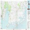
YellowMaps Anahuac TX topo map, 1:100000 Scale, 30 X 60 Minute, Historical, 1983, Updated 1983, 24.1 x 44 in - Tyvek
₪625.67
₪1,042.80
Save 40% (₪417.13)
-
 Order within 23 hours and 22 minutes to get between June 11 - June 17
 -
 Tracked Shipping on All Orders
-
 14-Day Returns
- Secure Payments
-
 24/7 Customer Support
Description
- Printed on Tyvek (synthetic)
- USGS topographic map of Anahuac, TX, at 1:100000 scale. Lighter material. Waterproof. Tear-resistant. Foldable. Very durable. Perfect for backpacking and the outdoors.
- Cities, towns, villages: Gilchrist,Quail Hollow,Stowell,Winnie,Timber Lake Estates,Smith Point,Hebert,Morgans Point,Cheek,Shiloh,Bacliff,Baytown,Country Club Estates,Beauxart Gardens,Eminence,Roseland Manor,Chaparral Village,Oak Island,Morey,Surf Oaks,Wallisville,Ginger Green,Viterbo,Mont Belvieu,Old River Community,Sea Breeze,Monroe City,San Jacinto Place,Eldon,South Dayton,Double Bayou,La Belle,Country Club Cove,High Island,Central Gardens,Chase Park,Cedar Bayou,Lovell Lake
- Mountains: Cedar Hill,Barbers Hill,Mesquite Knoll,Big Hill
- Valleys: Pignut Gully,Hackberry Gully,Jacks Gully,Buck Gully,Kidd Gully,Buck Gully,Green Pond Gully,Hatcher Gully,Saw Pit Gully,Pine Gully,Buck Gully,Red Haw Gully,Aubey Gully,Ground Bridge Gully,Sutton Gully
USGS topographic map of Anahuac, Texas, dated 1983, updated 1983.
Includes geographic coordinates (latitude and longitude), lines of elevation, bodies of water, roads, and more. This topo quad is suitable for recreational, outdoor uses, office applications, or wall map framing.
Printed on-demand by YellowMaps on the print material of your choice.
Shipping rolled from Minneapolis, MN, United States.
Product Number: USGS-5479687
Map Size: 24.1 inches high x 44 inches wide
Map Scale: 1:100000
Map Type: POD USGS Topographic Map
Map Series: HTMC
Map Version: Historical
Cell ID: 67047
Scan ID: 108166
Imprint Year: 1983
Woodland Tint: Yes
Visual Version Number: 2
Aerial Photo Year: 1982
Edit Year: 1983
Datum: NAD27
Map Projection: Universal Transverse Mercator
Map published by United States Geological Survey
Map Language: English
Scanner Resolution: 600 dpi
Map Cell Name: Anahuac
Grid size: 30 X 60 Minute
Date on map: 1983
Geographical region: Texas, United States
Northern map edge Latitude: 30
Southern map edge Latitude: 29.5
Western map edge Longitude: -95
Eastern map edge Longitude: -94
Surrounding map sheets (copy & paste the Product No. in the search bar):
North: USGS-5484867,USGS-5478799,USGS-5480579,USGS-5479709,USGS-5478797
East: USGS-5479239,USGS-5480051,USGS-5479241
South: USGS-5479871,USGS-5677884,USGS-5495293,USGS-5495301,USGS-5477905
West: USGS-5489139,USGS-5479905,USGS-5489147,USGS-5477881,USGS-5677680
Shipping and Returns
- We offer tracked shipping on all orders. Tracking information will be shared as soon as the order is dispatched.
- Please check the delivery estimate before adding a product to the cart. This is displayed for every product on the website.
- Available shipping methods and charges will be displayed at the time of checkout, depending on your exact location.
- All customers are entitled to a return window of 14 days, starting from the date of delivery of the product(s).
- Customers are advised to read our return policy for details of the return process, eligibility, refunds as well as cancellations or exchanges.
- In case of any issues or concerns about Shipping or Returns, please contact us and we will be happy to help.
YellowMaps.
YellowMaps Anahuac TX topo map, 1:100000 Scale, 30 X 60 M...
₪625.67
₪1,042.80
Save 40.0% (₪417.13)