
YELLOWMAPS
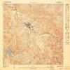
YellowMaps Adjuntas SO PR topo map, 1:10000 Scale, 3.75 X 3.75 Minute, Historical, 1947, 31.3 x 30.4 in - Polypropylene
₪587.23
₪978.72
Save 40% (₪391.49)
-
 Order within 23 hours and 21 minutes to get between June 11 - June 17
 -
 Tracked Shipping on All Orders
-
 14-Day Returns
- Secure Payments
-
 24/7 Customer Support
Description
- Printed on Polypropylene (plastic)
- USGS topographic map of Adjuntas SO, PR, at 1:10000 scale. Heavier material. Waterproof. Tear-resistant. Foldable. Perfect for the outdoors.
- Cities, towns, villages: Residencial Alturas de Adjuntas,Adjuntas Zona Urbana,Barriada Vega,Adjuntas,Joaquin M Andino,Jardin de Adjuntas,Los Maestros,Los Cerros,Residencial Valle Verde,San Felipe,Sector Olimpia,Barriada Rodriguez,San Joaquin
- Islands: Consult topo map preview for visible islands.
- Parks and forests: Complejo Recreativo Guarionex
USGS topographic map of Adjuntas SO, Puerto Rico, dated 1947.
Includes geographic coordinates (latitude and longitude), lines of elevation, bodies of water, roads, and more. This topo quad is suitable for recreational, outdoor uses, office applications, or wall map framing.
Printed on-demand by YellowMaps on the print material of your choice.
Shipping rolled from Minneapolis, MN, United States.
Product Number: USGS-5654004
Map Size: 31.3 inches high x 30.4 inches wide
Map Scale: 1:10000
Map Type: POD USGS Topographic Map
Map Series: HTMC
Map Version: Historical
Cell ID: 285962
Scan ID: 361919
Survey Year: 1943
Datum: Unstated
Map Projection: Polyconic
Map published by United States Geological Survey
Map Language: Spanish
Scanner Resolution: 600 dpi
Map Cell Name: Adjuntas SW
Grid size: 3.75 X 3.75 Minute
Date on map: 1947
Geographical region: Puerto Rico, United States
Northern map edge Latitude: 18.1875
Southern map edge Latitude: 18.125
Western map edge Longitude: -66.75
Eastern map edge Longitude: -66.6875
Surrounding map sheets (copy & paste the Product No. in the search bar):
North: USGS-5654000
East: USGS-5654002
South: USGS-5654900,USGS-5655436,USGS-5655434,USGS-5654894,USGS-5654898
West: USGS-5654848,USGS-5655388,USGS-5655386,USGS-5654850,USGS-5655384
Shipping and Returns
- We offer tracked shipping on all orders. Tracking information will be shared as soon as the order is dispatched.
- Please check the delivery estimate before adding a product to the cart. This is displayed for every product on the website.
- Available shipping methods and charges will be displayed at the time of checkout, depending on your exact location.
- All customers are entitled to a return window of 14 days, starting from the date of delivery of the product(s).
- Customers are advised to read our return policy for details of the return process, eligibility, refunds as well as cancellations or exchanges.
- In case of any issues or concerns about Shipping or Returns, please contact us and we will be happy to help.
YellowMaps.
YellowMaps Adjuntas SO PR topo map, 1:10000 Scale, 3.75 X...
₪587.23
₪978.72
Save 40.0% (₪391.49)