
YELLOWMAPS
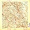
Mt Lyell CA topo map, 1:125000 Scale, 30 X 30 Minute, Historical, 1901, Updated 1901, 19.9 x 16.5 in - Tyvek
₪589.24
₪982.07
-
 Order within 13 hours and 4 minutes to get between June 11 - June 17
 -
 Tracked Shipping on All Orders
-
 14-Day Returns
- Secure Payments
-
 24/7 Customer Support
Description
- Printed on Tyvek (synthetic)
- USGS topographic map of Mt Lyell, CA, at 1:125000 scale. Lighter material. Waterproof. Tear-resistant. Foldable. Very durable. Perfect for backpacking and the outdoors.
- Cities, towns, villages: June Lake Junction,June Lake,Lake Mary,Lee Vining,Bennettville (historical)
- Mountains: Ritter Range,Cathedral Range,Clark Range,Balls,Aeolian Buttes,White Mountain,Pywiack Dome,Junction Butte,Rodgers Peak,Red Top Mountain,Obsidian Dome,Isberg Peak,Williams Butte,Amelia Earhart Peak,Clouds Rest,Unicorn Peak,Sunrise Mountain
- Valleys: Matterhorn Canyon,Gibbs Canyon,Sawmill Canyon,Beartrack Canyon,Lee Vining Canyon,Bench Canyon,Snow Canyon,Virginia Canyon,Clark Canyon,Lyell Canyon,Fish Valley,Bloody Canyon,Glacier Canyon
USGS topographic map of Mt Lyell, California, dated 1901, updated 1901.
Includes geographic coordinates (latitude and longitude), lines of elevation, bodies of water, roads, and more. This topo quad is suitable for recreational, outdoor uses, office applications, or wall map framing.
Printed on-demand by YellowMaps on the print material of your choice.
Shipping rolled from Minneapolis, MN, United States.
Product Number: USGS-5637623
Map Size: 19.9 inches high x 16.5 inches wide
Map Scale: 1:125000
Map Type: POD USGS Topographic Map
Map Series: HTMC
Map Version: Historical
Cell ID: 395849
Scan ID: 299480
Imprint Year: 1901
Survey Year: 1899
Datum: Unstated
Map Projection: Unstated
Map published by United States Geological Survey
Map Language: English
Scanner Resolution: 600 dpi
Map Cell Name: Mount Lyell
Grid size: 30 X 30 Minute
Date on map: 1901
Geographical region: California, United States
Northern map edge Latitude: 38
Southern map edge Latitude: 37.5
Western map edge Longitude: -119.5
Eastern map edge Longitude: -119
Surrounding map sheets (copy & paste the Product No. in the search bar):
North: USGS-5505585,USGS-5505589,USGS-5502897,USGS-5505597,USGS-5502895
East: USGS-5503199,USGS-5505205,USGS-5508803,USGS-5503203,USGS-5505203
South: USGS-5505877,USGS-5505887,USGS-5505879,USGS-5505881,USGS-5504515
West: USGS-5505191,USGS-5506463,USGS-5506461,USGS-5506465,USGS-5506459
Shipping and Returns
- We offer tracked shipping on all orders. Tracking information will be shared as soon as the order is dispatched.
- Please check the delivery estimate before adding a product to the cart. This is displayed for every product on the website.
- Available shipping methods and charges will be displayed at the time of checkout, depending on your exact location.
- All customers are entitled to a return window of 14 days, starting from the date of delivery of the product(s).
- Customers are advised to read our return policy for details of the return process, eligibility, refunds as well as cancellations or exchanges.
- In case of any issues or concerns about Shipping or Returns, please contact us and we will be happy to help.
YellowMaps.
Mt Lyell CA topo map, 1:125000 Scale, 30 X 30 Minute, His...
₪589.24
₪982.07